The Mississippi has long been used for transportation; however, navigation has been forced to accommodate its whims; deep-flowing but turbulent in times of flooding; placid but shallow to the point of non-navigability in times of drought. Other obstacles included swift and treacherous rapids, submerged rocks and boulders and uncharted sand bars and tree snags, which ended the life of many steamers in the nineteenth century.
As early as the 1830s, the federal government began improvements on the river in the interest of navigation. In 1930, after extensive studies by the U.S. Army Corps of Engineers, Congress authorized the nine-foot channel navigation project on the Upper Mississippi River. This legislation provided for a navigation channel with a minimum 9-foot depth and a minimum width of 400 feet, to be achieved by construction of a system of locks and dams that create a series of slack water pools behind each dam, supplemented by dredging. Construction of this system mainly occurred in the decade 1930-1940.
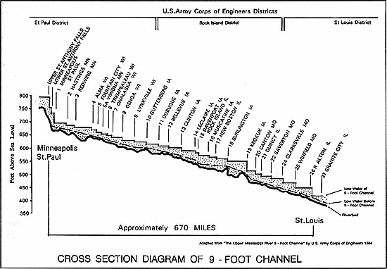
In the approximately 670 miles of river between the first lock at the Falls of St. Anthony area of Minneapolis-St. Paul, Minnesota, and the last lock of the project (Lock #27) at St. Louis, Missouri, the Mississippi has a fall of about 420 feet. The purpose of the locks and dams is to create a series of steps which river tows and other boats either climb or descend as they travel upstream or downstream. Locks and dams on the Mississippi were not built for flood control or to eliminate all the low spots caused by shoaling on the river bed (buildup of sediment causing a hazard to navigation).
the Upper Mississippi River lock and dam system
Why is there a need to dredge the river - Can't the dams keep the Mississippi River high enough to eliminate the need for dredging?
The Mississippi River 9-foot Channel Project provides a minimum 9-foot deep channel for commercial navigation. Each Mississippi River "pool" behind a dam has an authorized operating range and the water level is maintained within a narrow operating band with specific lower and upper operational limits. The Corps is required by law not to deviate from the range which is part of the authorized operating plan. Intentionally operating a pool outside of the authorized operating range to minimize dredging or minimize flooding would be in violation of the law.
The lower limit is the minimum water level required to maintain the 9-foot channel. The upper limit relates to the real estate (property) the federal government acquired when constructing the 9-foot navigation channel project that would be subject to flooding caused by putting the dams into operation. If any of the pools were to be operated above the upper authorized pool limit to offset the need for dredging when shoaling occurs, the Corps would be intentionally flooding lands it does not own or have easements on.
Since shoaling is a natural phenomenon occurring in all movable bed streams, even if more land was acquired and the pools were raised, shoaling would still occur, requiring dredging to keep the channel open for navigation.
Can raising the gates of navigation dams lower the Mississippi River and prevent flooding?
Over the years, the operation of the Corps' navigation dams has been questioned prior to or during a flood on the Mississippi River. Many times we are asked, "Why doesn't the Corps of Engineers raise the gates on the Mississippi River dams to reduce the pool levels (lower the river) now before the snow melt and spring rains to reduce the amount of flooding?"
There are many reasons why this idea is not practical.
The first, and foremost reason is that although they appear to be large flood control structures like a reservoir, locks and dams do not store water; they cannot prevent or cause flooding and they have no flood control capabilities. If the Mississippi River dams could control flooding, that is, hold back or store water, the pool created behind the dam would be so enormous that it would flood many communities.
The Mississippi River navigation dams were constructed to maintain a 9-foot-deep channel for the safe transport of commodities by commercial tows and provide no benefits for flood control. This is because the pools behind the dams do not contain sufficient storage capacity to accommodate flooding events. Raising the gates out of the water, weeks in advance of a predicted flood, would have no beneficial effect with regard to lowering the ultimate crest of a potential flood, but would have negative impacts to navigation and other infrastructure.
This is supported by the Iowa Institute for Hydraulic Research, University of Iowa, in a study conducted in August 1969 following the 1965 flood when the operation of the locks and dams came into question. The study, Effects of Navigation-Dam Operating Procedures on Mississippi River Flood Levels, was conducted to determine the effects of lowering the Mississippi River pools in advance of a flood. The study results state that "the procedure established by the Corps of Engineers for operating the gates at the navigation dams causes no increase in the crest levels of large floods over that which would occur if the gates were completely opened well in advance of the flood."
Even if each pool was completely emptied prior to an anticipated heavy runoff period, it would take only a matter of hours to refill them and this would not appreciably lower the peak river stages reached by the flood. This is because the amount of storage that could be made available by pool draw downs is extremely small in comparison with flood volumes.
It is normal to think of a dam as a huge solid structure used to block the flow of a river and form a lake. However, this is not true of navigation dams, like those on the Upper Mississippi River. These dams are not solid but are a series of concrete piers across the river with movable Tainter or roller gates between the piers.
The rollers and gates at Locks and Dam 15, as well as all other navigation dams, do not reach from the bed (bottom) of the river to above the water line. They are lowered into a portion of the river to cause the water level upstream of the dam to rise and form a slack-water pool deep enough for navigation. The rollers and gates on the dams restrict water flow near the top of the river; in essence, they put a drag on the flow to keep the pool behind the dam high enough to maintain the 9-foot deep navigation channel. While maintaining the 9-foot navigation channel all river flow passes through the dam under the gates.
The Corps is required by law to maintain the navigation channel and must maintain it to within +/- one-half foot. There are times, usually in spring, when the natural flow provides a channel deep enough for navigation without the use of the dams, such as we are experiencing on the Mississippi River this spring. When this occurs, the gates between the piers are raised completely out of the water and the river flows as an open river.
This spring (2011), the gates of the dams below the Quad Cities that maintain the river level at downtown Davenport, Iowa, and downtown Rock Island, Ill., were raised out of the river beginning in February. The gates of Lock and Dam 16 at Muscatine, Iowa, were raised on March 22; the gates of Lock and Dam 17 at New Boston, Ill., were raised on Feb. 19; the gates of Lock and Dam 18 at Gladstone, Ill., were raised on March 24; Dam 19 at Keokuk, Iowa, is a privately-owned hydroelectric dam operated by Ameren; the gates of Lock and Dam 20 at Canton, Mo., were raised on Feb. 17; the gates of Lock and Dam 21 at Quincy, Ill., were raised on March 24; and the gates of Lock and Dam 22 at Saverton, Mo., were raised on March 25.
The gates of Locks and Dam 15 at Rock Island, Ill., which control river levels in Mississippi River pool 15 east of downtown Davenport, Iowa, were raised out of the water on April 5.
Although gates were raised and the Mississippi River flowed without restriction, the River continued to rise in the Quad Cities. The river peaked (crested) at about 20.7 feet on April 23, 2011, then began to fall as snow melt and spring rains tapered off.
A second reason is that since the Mississippi River maintains it flow through water (rain and snow melt) draining into the river from 41 percent of the continental United States stretching from Montana to New York (31 states and two Canadian provinces), it would be very difficult to lower the river and maintain those levels.
To attempt to lower or empty a pool would require blocking (damming) the flow of the Mississippi River upstream and the inflows from streams and smaller rivers emptying into the pool. If the river was dammed in this way, the Mississippi River, streams and smaller rivers would back up and cause flooding upstream.
The amount of water in a navigation pool is insignificant during times of flooding and if it were possible to empty the navigation pools it would not last very long. The 1969 University of Iowa study conclusively showed that flood levels are not affected by the time gates of the dams are opened whether that is days, weeks or months before the arrival of a flood.
Reason number three is that there are many other economic and environmental factors as to why we wouldn't lower the navigation pools. Those factors include loss of water intakes for municipal water supplies, manufacturing industries and power generating plants; loss of commercial navigation channel (March 1 onwards); impacts to docks, commercial riverboats (e.g., casinos), and recreational craft; bank sloughing and impacts to levees and shoreline; negative impacts to fish and wildlife habitat; loss of recreational opportunities (fishing, boating, etc.); to name a few.
To attempt this would require coordination with the Fish and Wildlife Service, the U.S. Coast Guard, the Departments of Natural Resources, numerous other federal, state, local and non-government agencies, and the public; and would require compliance with a variety of federal and state regulations to include the National Environmental Policy Act, the Endangered Species Act, the Clean Water Act and the National Historic Preservation Act.
A fourth reason why the Corps doesn't lower Mississippi River pools is that it is illegal to do so above Lock and Dam 15 in Rock Island in accordance with the Anti-Drawdown Law. This act of Congress, dated March 10, 1934, is entitled, "An act to promote the conservation of wildlife, fish, and game, and for other purposes," as amended by Public Law 732 on August 14, 1946, and again by Public Law 697 on June 19, 1948.
The "Anti-drawdown Law" directs that in the management of facilities (including locks, dams and pools) on the Mississippi River between Rock Island, Illinois, and Minneapolis, Minnesota, administered by the U.S. Army Corps of Engineers, full consideration and recognition is to be given to the needs of fish and other wildlife resources, including habitat. To the maximum extent possible, the law directs that the Corps regulation of the navigation pools take the needs of these natural resources into account, while maintaining navigation, without causing damage to property, and without creating additional liability to the government. The law also directs that the Corps shall generally operate and maintain pool levels as though navigation were carried on throughout the year.
For more detailed information about the District's locks and dams, please visit the following link: